A supervised land cover classification of a western Kenya lowland endemic for human malaria: associations of land cover with larval Anopheles habitats
Supporting Files
Public Domain

-
Apr 16 2009
-
File Language:
English
Details
-
Alternative Title:Int J Health Geogr
-
Personal Author:Mutuku, FM ; Bayoh, MN ; Hightower, AW ; Vulule, JM ; Gimnig, JE ; Mueke, JM ; Amimo, FA ; Walker, ED
-
Description:Background
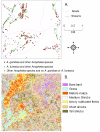
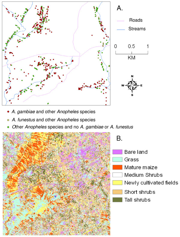
A supervised land cover classification was developed from very high resolution IKONOS satellite data and extensive ground truth sampling of a ca. 10 sq km malaria-endemic lowland in western Kenya. The classification was then applied to an investigation of distribution of larval Anopheles habitats. The hypothesis was that the distribution and abundance of aquatic habitats of larvae of various species of mosquitoes in the genus Anopheles is associated with identifiable landscape features.
Results and discussion
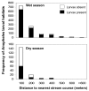
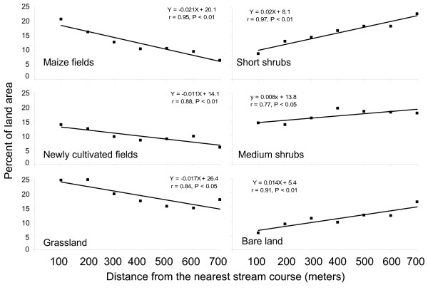
The classification resulted in 7 distinguishable land cover types, each with a distinguishable vegetation pattern, was highly accurate (89%, Kappa statistic = 0.86), and had a low rate of omission and commission errors. A total of 1,198 habitats and 19,776 Anopheles larvae of 9 species were quantified in samples from a rainy season, and 184 habitats and 582 larvae from a dry season. Anopheles gambiae s.l. was the dominant species complex (51% of total) and A. arabiensis the dominant species. Agricultural land covers (mature maize fields, newly cultivated fields, and pastured grasslands) were positively associated with presence of larval habitats, and were located relatively close to stream channels; whilst nonagricultural land covers (short shrubs, medium shrubs, tall shrubs, and bare soil around residences) were negatively associated with presence of larval habitats and were more distant from stream channels. Number of larval habitats declined exponentially with distance from streams. IKONOS imagery was not useful in direct detection of larval habitats because they were small and turbid (resembling bare soil), but was useful in localization of them through statistical associations with specific land covers.
Conclusion
A supervised classification of land cover types in rural, lowland, western Kenya revealed a largely human-modified and fragmented landscape consisting of agricultural and domestic land uses. Within it, larval habitats of Anopheles vectors of human malaria were associated with certain land cover types, of largely agricultural origin, and close to streams. Knowledge of these associations can inform malaria control to gather information on potential larval habitats more efficiently than by field survey and can do so over large areas.
-
Subjects:
-
Source:Int J Health Geogr. 2009; 8:19.
-
Document Type:
-
Place as Subject:
-
Volume:8
-
Collection(s):
-
Main Document Checksum:urn:sha-512:13c8e2d97533931ee07ba17a18421df90599ac85d94599bec3ba851e791960209f876c48213347236b78f47842c1ecc78b0e58bb20fe812dc675ef74e5d03f8c
-
Download URL:
-
File Type:
 [PDF
- 432.12 KB
]
[PDF
- 432.12 KB
]
Supporting Files

File Language:
English
ON THIS PAGE

CDC STACKS serves as an archival repository of CDC-published products including
scientific findings,
journal articles, guidelines, recommendations, or other public health information authored or
co-authored by CDC or funded partners.
As a repository, CDC STACKS retains documents in their original published format to ensure public access to scientific information.
As a repository, CDC STACKS retains documents in their original published format to ensure public access to scientific information.
You May Also Like
COLLECTION
CDC Public Access