Progress in Pediatric Asthma Surveillance II: Geospatial Patterns of Asthma in Alameda County, California
Supporting Files
Public Domain

-
Jun 15 2006
-
File Language:
English
Details
-
Journal Article:Preventing Chronic Disease (PCD)
-
Personal Author:
-
Description:Introduction
As with many diseases, the epidemic of asthma among children over the past few decades has been shaped by a social and environmental context that is becoming progressively more evident. Commonly used methods for asthma surveillance, however, are based on national rather than local data. The purpose of this study was to develop high-resolution asthma surveillance techniques responsive to the needs of health care professionals and local child health and social justice advocates.
Methods
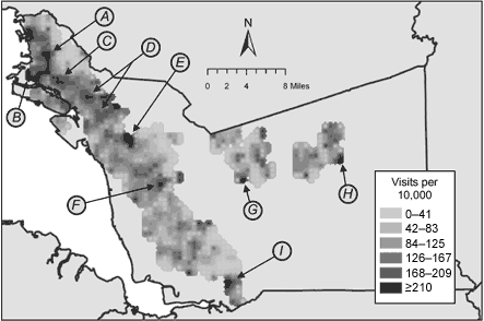
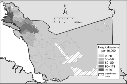
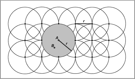
We assembled a working data set of health care use records from 2001 from public and private sources covering 1.7 million person-months among children younger than 18 years in Alameda County, California. Health care use was categorized by type and analyzed by census tract demographic information. Images of the geographic distribution of health service events were created using density estimation mapping with overlapping 0.5-mile (805-m) radius spatial buffers, and statistical significance (two-tailed P < .05) was estimated using a Monte Carlo simulation algorithm.
Results
High-poverty communities had higher rates of emergency department visits due to asthma than low-poverty communities but had lower rates for indicators of quality primary asthma care. Geospatial analysis enabled visualization of this phenomenon; it further detected areas with elevated emergency department visit rates and potentially related environmental hazards in and around communities of concern. Areas of the county not previously considered to be deeply burdened by asthma were identified as having high emergency department visit rates.
Conclusion
The assembly and high-resolution geospatial analysis of health care use data contributed to a more detailed depiction of pediatric asthma disparities than was previously available to community members, public health professionals, and clinicians. Information generated using these techniques facilitated discussion among stakeholders of the environmental and social contexts of asthma and health disparities in general. Proceedings of group evaluations suggested that the material aided in the translation of data describing spatial variations in health event risk to address specific community experiences and concerns.
-
Subjects:
-
Source:Prev Chronic Dis. 2006; 3(3).
-
ISSN:1545-1151
-
Document Type:
-
Place as Subject:
-
Location:
-
Volume:3
-
Issue:3
-
Collection(s):
-
Main Document Checksum:urn:sha-512:221661fdbd60c3e2f601d724728d102e5a2f860f187296863aef5f6f882d2186b3d030cde20c3c1e1f5096415997ca136281f5853a03fa0bae9ebf119df65da7
-
Download URL:
-
File Type:
 [PDF
- 425.15 KB
]
[PDF
- 425.15 KB
]
Supporting Files

File Language:
English
ON THIS PAGE

CDC STACKS serves as an archival repository of CDC-published products including
scientific findings,
journal articles, guidelines, recommendations, or other public health information authored or
co-authored by CDC or funded partners.
As a repository, CDC STACKS retains documents in their original published format to ensure public access to scientific information.
As a repository, CDC STACKS retains documents in their original published format to ensure public access to scientific information.
You May Also Like
COLLECTION
Preventing Chronic Disease