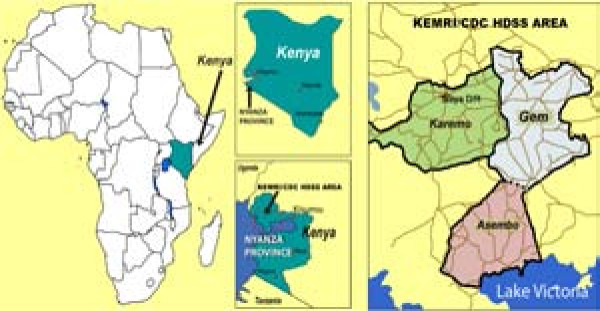
Spatial and temporal dynamics of malaria transmission in rural Western Kenya
Supporting Files
Public Domain

-
Apr 28 2012
-
File Language:
English
Details
-
Alternative Title:Parasit Vectors
-
Personal Author:
-
Description:Background
Understanding the relationship between Plasmodium falciparum malaria transmission and health outcomes requires accurate estimates of exposure to infectious mosquitoes. However, measures of exposure such as mosquito density and entomological inoculation rate (EIR) are generally aggregated over large areas and time periods, biasing the outcome-exposure relationship. There are few studies examining the extent and drivers of local variation in malaria exposure in endemic areas.
Methods
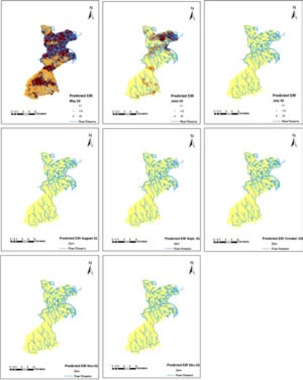
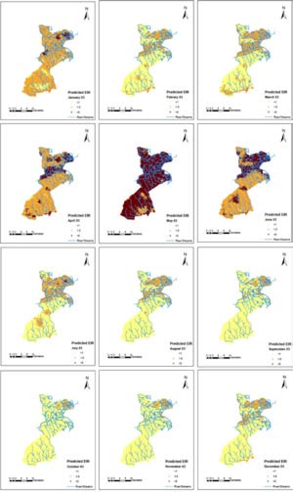
We describe the spatio-temporal dynamics of malaria transmission intensity measured by mosquito density and EIR in the KEMRI/CDC health and demographic surveillance system using entomological data collected during 2002–2004. Geostatistical zero inflated binomial and negative binomial models were applied to obtain location specific (house) estimates of sporozoite rates and mosquito densities respectively. Model-based predictions were multiplied to estimate the spatial pattern of annual entomological inoculation rate, a measure of the number of infective bites a person receive per unit of time. The models included environmental and climatic predictors extracted from satellite data, harmonic seasonal trends and parameters describing space-time correlation.
Results
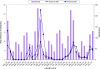
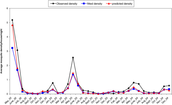
Anopheles gambiae s.l was the main vector species accounting for 86 % (n = 2309) of the total mosquitoes collected with the remainder being Anopheles funestus. Sixty eight percent (757/1110) of the surveyed houses had no mosquitoes. Distance to water bodies, vegetation and day temperature were strongly associated with mosquito density. Overall annual point estimates of EIR were 6.7, 9.3 and 9.6 infectious bites per annum for 2002, 2003 and 2004 respectively. Monthly mosquito density and EIR varied over the study period peaking in May during the wet season each year. The predicted and observed densities of mosquitoes and EIR showed a strong seasonal and spatial pattern over the study area.
Conclusions
Spatio-temporal maps of malaria transmission intensity obtained in this study are not only useful in understanding variability in malaria epidemiology over small areas but also provide a high resolution exposure surface that can be used to analyse the impact of transmission on malaria related and all-cause morbidity and mortality.
-
Subjects:
-
Source:Parasit Vectors. 2012; 5:86.
-
Document Type:
-
Place as Subject:
-
Volume:5
-
Collection(s):
-
Main Document Checksum:urn:sha256:2905f41d3084e9fcde2a1fa10b24dfb41edc3c3244a1cd79a129c78b856143b2
-
Download URL:
-
File Type:
 [PDF
- 1.73 MB
]
[PDF
- 1.73 MB
]
Supporting Files

File Language:
English
ON THIS PAGE

CDC STACKS serves as an archival repository of CDC-published products including
scientific findings,
journal articles, guidelines, recommendations, or other public health information authored or
co-authored by CDC or funded partners.
As a repository, CDC STACKS retains documents in their original published format to ensure public access to scientific information.
As a repository, CDC STACKS retains documents in their original published format to ensure public access to scientific information.
You May Also Like
COLLECTION
CDC Public Access