Estimating Wildfire Smoke Concentrations During the October 2017 California Fires Through BME Space/Time Data Fusion of Observed, Modeled, and Satellite-Derived PM2.5
Supporting Files

-
11 03 2020
-
File Language:
English
Details
-
Alternative Title:Environ Sci Technol
-
Personal Author:
-
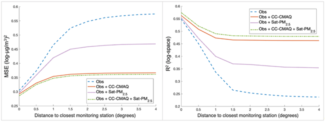
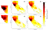
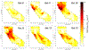
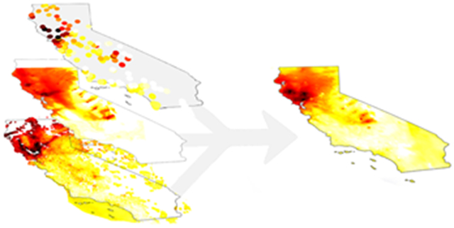
Description:Exposure to wildfire smoke causes adverse health outcomes, suggesting the importance of accurately estimating smoke concentrations. Geostatistical methods can combine observed, modeled, and satellite-derived concentrations to produce accurate estimates. Here, we estimate daily average ground-level PM| concentrations at a 1 km resolution during the October 2017 California wildfires, using the Constant Air Quality Model Performance (CAMP) and Bayesian Maximum Entropy (BME) methods to bias-correct and fuse three concentration datasets: permanent and temporary monitoring stations, a chemical transport model (CTM), and satellite-derived estimates. Four BME space/time kriging and data fusion methods were evaluated. All BME methods produce more accurate estimates than the standalone CTM and satellite products. Adding temporary station data increases the | by 36%. The data fusion of observations with the CAMP-corrected CTM and satellite-derived concentrations provides the best estimate (| = 0.713) in fire-impacted regions, emphasizing the importance of combining multiple datasets. We estimate that approximately 65,000 people were exposed to very unhealthy air (daily average PM| ≥ 150.5 μg/m|).
-
Subjects:
-
Source:Environ Sci Technol. 54(21):13439-13447
-
Pubmed ID:33064454
-
Pubmed Central ID:PMC7894965
-
Document Type:
-
Funding:
-
Place as Subject:
-
Volume:54
-
Issue:21
-
Collection(s):
-
Main Document Checksum:urn:sha256:2401404a6e6cf661b8dc4989ef8547638a95ed39086f7c45603f8e655c6086cb
-
Download URL:
-
File Type:
 [PDF
- 628.43 KB
]
[PDF
- 628.43 KB
]
Supporting Files

File Language:
English
ON THIS PAGE

CDC STACKS serves as an archival repository of CDC-published products including
scientific findings,
journal articles, guidelines, recommendations, or other public health information authored or
co-authored by CDC or funded partners.
As a repository, CDC STACKS retains documents in their original published format to ensure public access to scientific information.
As a repository, CDC STACKS retains documents in their original published format to ensure public access to scientific information.
You May Also Like
COLLECTION
CDC Public Access