Estimating the Burden of Malaria in Senegal: Bayesian Zero-Inflated Binomial Geostatistical Modeling of the MIS 2008 Data
Supporting Files
Public Domain

-
Mar 05 2012
-
File Language:
English
Details
-
Alternative Title:PLoS One
-
Personal Author:
-
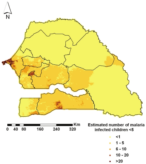
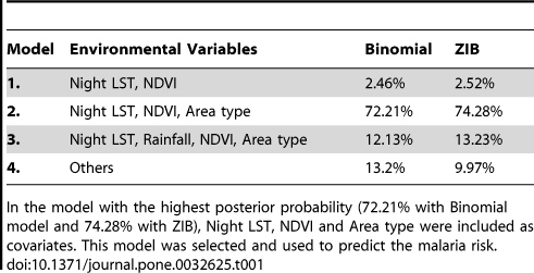
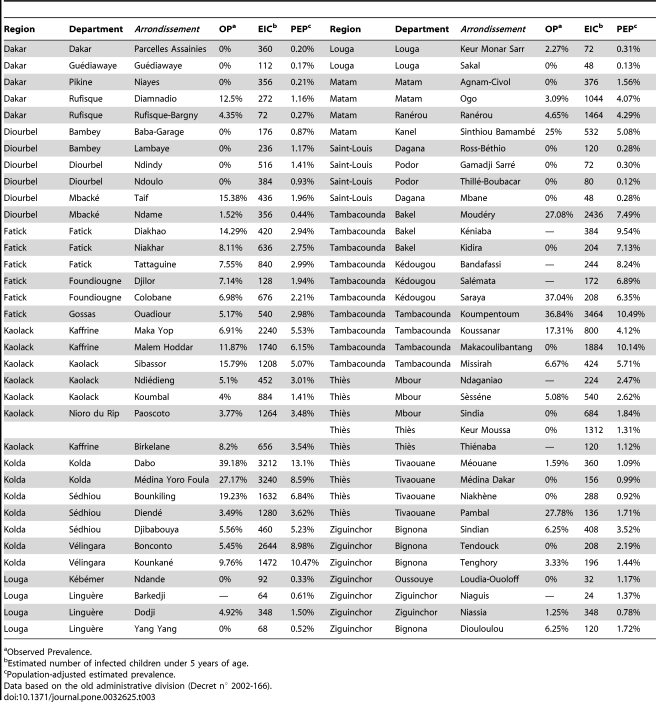
Description:The Research Center for Human Development in Dakar (CRDH) with the technical assistance of ICF Macro and the National Malaria Control Programme (NMCP) conducted in 2008/2009 the Senegal Malaria Indicator Survey (SMIS), the first nationally representative household survey collecting parasitological data and malaria-related indicators. In this paper, we present spatially explicit parasitaemia risk estimates and number of infected children below 5 years. Geostatistical Zero-Inflated Binomial models (ZIB) were developed to take into account the large number of zero-prevalence survey locations (70%) in the data. Bayesian variable selection methods were incorporated within a geostatistical framework in order to choose the best set of environmental and climatic covariates associated with the parasitaemia risk. Model validation confirmed that the ZIB model had a better predictive ability than the standard Binomial analogue. Markov chain Monte Carlo (MCMC) methods were used for inference. Several insecticide treated nets (ITN) coverage indicators were calculated to assess the effectiveness of interventions. After adjusting for climatic and socio-economic factors, the presence of at least one ITN per every two household members and living in urban areas reduced the odds of parasitaemia by 86% and 81% respectively. Posterior estimates of the ORs related to the wealth index show a decreasing trend with the quintiles. Infection odds appear to be increasing with age. The population-adjusted prevalence ranges from 0.12% in Thillé-Boubacar to 13.1% in Dabo. Tambacounda has the highest population-adjusted predicted prevalence (8.08%) whereas the region with the highest estimated number of infected children under the age of 5 years is Kolda (13940). The contemporary map and estimates of malaria burden identify the priority areas for future control interventions and provide baseline information for monitoring and evaluation. Zero-Inflated formulations are more appropriate in modeling sparse geostatistical survey data, expected to arise more frequently as malaria research is focused on elimination.
-
Subjects:
-
Source:PLoS One. 2012; 7(3).
-
Document Type:
-
Place as Subject:
-
Volume:7
-
Issue:3
-
Collection(s):
-
Main Document Checksum:urn:sha256:cea1a95efd0dabc71938760b5196390a50dea00050b957d53e2ba13539b217ac
-
Download URL:
-
File Type:
 [PDF
- 492.13 KB
]
[PDF
- 492.13 KB
]
Supporting Files

File Language:
English
ON THIS PAGE

CDC STACKS serves as an archival repository of CDC-published products including
scientific findings,
journal articles, guidelines, recommendations, or other public health information authored or
co-authored by CDC or funded partners.
As a repository, CDC STACKS retains documents in their original published format to ensure public access to scientific information.
As a repository, CDC STACKS retains documents in their original published format to ensure public access to scientific information.
You May Also Like
COLLECTION
CDC Public Access