Use of Geospatial Modeling to Predict Schistosoma mansoni Prevalence in Nyanza Province, Kenya
Supporting Files
Public Domain

-
Aug 14 2013
-
File Language:
English
Details
-
Alternative Title:PLoS One
-
Personal Author:
-
Description:Background
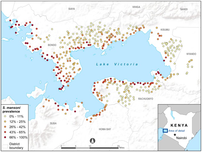
Schistosomiasis, a parasitic disease that affects over 200 million people, can lead to significant morbidity and mortality; distribution of single dose preventative chemotherapy significantly reduces disease burden. Implementation of control programs is dictated by disease prevalence rates, which are determined by costly and labor intensive screening of stool samples. Because ecological and human factors are known to contribute to the focal distribution of schistosomiasis, we sought to determine if specific environmental and geographic factors could be used to accurately predict Schistosoma mansoni prevalence in Nyanza Province, Kenya.
Methodology/Principal Findings
A spatial mixed model was fit to assess associations with S. mansoni prevalence in schools. Data on S. mansoni prevalence and GPS location of the school were obtained from 457 primary schools. Environmental and geographic data layers were obtained from publicly available sources. Spatial models were constructed using ArcGIS 10 and R 2.13.0. Lower S.mansoni prevalence was associated with further distance (km) to Lake Victoria, higher day land surface temperature (LST), and higher monthly rainfall totals. Altitude, night LST, human influence index, normalized difference vegetation index, soil pH, soil texture, soil bulk density, soil water capacity, population, and land use variables were not significantly associated with S. mansoni prevalence.
Conclusions
Our model suggests that there are specific environmental and geographic factors that influence S. mansoni prevalence rates in Nyanza Province, Kenya. Validation and use of schistosomiasis prevalence maps will allow control programs to plan and prioritize efficient control campaigns to decrease schistosomiasis burden.
-
Subjects:
-
Source:PLoS One. 2013; 8(8).
-
Document Type:
-
Place as Subject:
-
Volume:8
-
Issue:8
-
Collection(s):
-
Main Document Checksum:urn:sha256:a72bd907b007e7770bdfb70194048c907a8d5776f3eee4bba29380cc4e978b28
-
Download URL:
-
File Type:
 [PDF
- 3.77 MB
]
[PDF
- 3.77 MB
]
Supporting Files

File Language:
English
ON THIS PAGE

CDC STACKS serves as an archival repository of CDC-published products including
scientific findings,
journal articles, guidelines, recommendations, or other public health information authored or
co-authored by CDC or funded partners.
As a repository, CDC STACKS retains documents in their original published format to ensure public access to scientific information.
As a repository, CDC STACKS retains documents in their original published format to ensure public access to scientific information.
You May Also Like
COLLECTION
CDC Public Access