Modeling future climate suitability for the western blacklegged tick, Ixodes pacificus, in California with an emphasis on land access and ownership
Supporting Files

-
9 2021
-
File Language:
English
Details
-
Alternative Title:Ticks Tick Borne Dis
-
Personal Author:
-
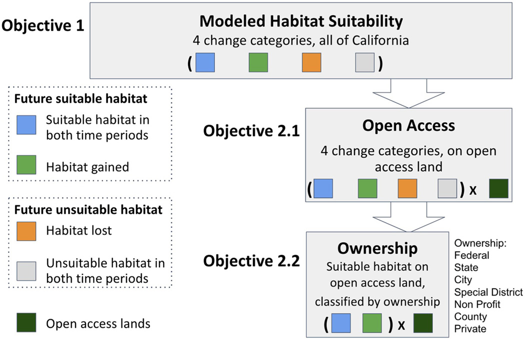
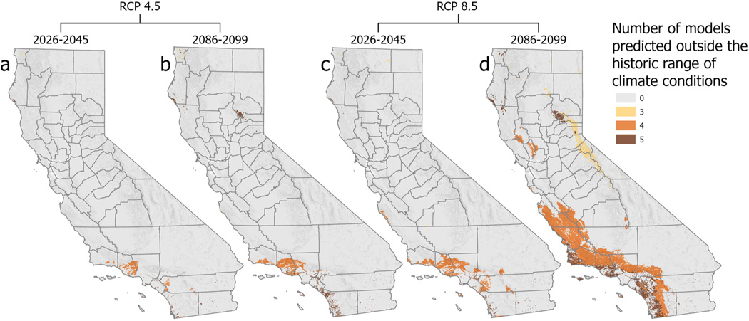
Description:In the western United States, Ixodes pacificus Cooley & Kohls (Acari: Ixodidae) is the primary vector of the agents causing Lyme disease and granulocytic anaplasmosis in humans. The geographic distribution of the tick is associated with climatic variables that include temperature, precipitation, and humidity, and biotic factors such as the spatial distribution of its primary vertebrate hosts. Here, we explore (1) how climate change may alter the geographic distribution of I. pacificus in California, USA, during the 21| century, and (2) the spatial overlap among predicted changes in tick habitat suitability, land access, and ownership. Maps of potential future suitability for I. pacificus were generated by applying climate-based species distribution models to a multi-model ensemble of climate change projections for the Representative Concentration Pathway (RCP) 4.5 (moderate emission) and 8.5 (high emission) scenarios for two future periods: mid-century (2026-2045) and end-of-century (2086-2099). Areas climatically-suitable for I. pacificus are projected to expand by 23% (mid-century RCP 4.5) to 86% (end-of-century RCP 8.5) across California, compared to the historical period (1980-2014), with future estimates of total suitable land area ranging from about 88 to 133 thousand km|, or up to about a third of California. Regions projected to have the largest area increases in suitability by end-of-century are in northwestern California and the south central and southern coastal ranges. Over a third of the future suitable habitat is on lands currently designated as open access (i.e. publicly available), and by 2100, the amount of these lands that are suitable habitat for I. pacificus is projected to more than double under the most extreme emissions scenario (from ~23,000 to >51,000 km|). Of this area, most is federally-owned (>45,000 km|). By the end of the century, 26% of all federal land in the state is predicted to be suitable habitat for I. pacificus. The resulting maps may facilitate regional planning and preparedness by informing public health and vector control decision-makers.
-
Subjects:
-
Keywords:
-
Source:Ticks Tick Borne Dis. 12(5):101789
-
Pubmed ID:34280699
-
Pubmed Central ID:PMC9379859
-
Document Type:
-
Funding:
-
Volume:12
-
Issue:5
-
Collection(s):
-
Main Document Checksum:urn:sha-512:1f67f74e29a21d2e0f9a80dfe7c486933570742376f6c6ce77400ead2d51692ae82d31acc8256921931975c8fa23ec871b03f443789a16f01bda0c11279c2817
-
Download URL:
-
File Type:
 [PDF
- 1.47 MB
]
[PDF
- 1.47 MB
]
Supporting Files

File Language:
English
ON THIS PAGE

CDC STACKS serves as an archival repository of CDC-published products including
scientific findings,
journal articles, guidelines, recommendations, or other public health information authored or
co-authored by CDC or funded partners.
As a repository, CDC STACKS retains documents in their original published format to ensure public access to scientific information.
As a repository, CDC STACKS retains documents in their original published format to ensure public access to scientific information.
You May Also Like
COLLECTION
CDC Public Access