Using search-constrained inverse distance weight modeling for near real-time riverine flood modeling: Harris County, Texas, USA before, during, and after Hurricane Harvey
Supporting Files

-
9 15 2021
-
File Language:
English
Details
-
Alternative Title:Nat Hazards (Dordr)
-
Personal Author:
-
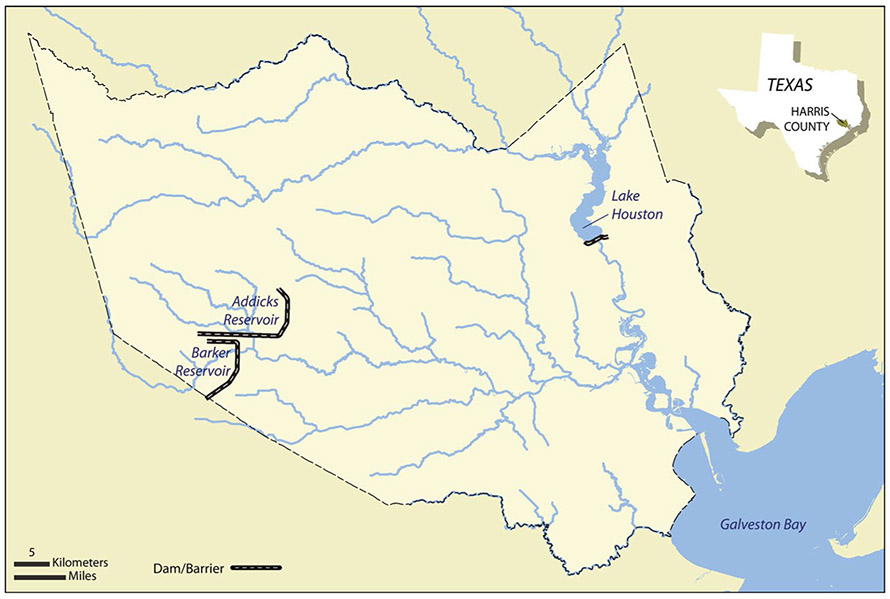
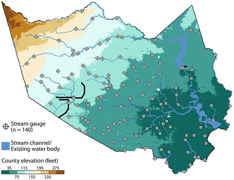
Description:Flooding poses a serious public health hazard throughout the world. Flood modeling is an important tool for emergency preparedness and response, but some common methods require a high degree of expertise or may be unworkable due to poor data quality or data availability issues. The conceptually simple method of inverse distance weight modeling offers an alternative. Using stream gauges as inputs, this study interpolated stream elevation via inverse distance weight modeling under 15 different model input parameter scenarios for Harris County, Texas, USA, from August 25th to September 15th, 2017 (before, during, and after Hurricane Harvey inundated the county). A digital elevation model was used to identify areas where modeled stream elevation exceeded ground elevation, indicating flooding. Imagery and observed high water marks were used to validate the models' outputs. There was a high degree of agreement (between 79 and 88%) between imagery and model outputs of parameterizations visually validated. Quantitative validations based on high water marks were also positive, with a Nash-Sutcliffe efficiency of in excess of .6 for all parameterizations relative to a Nash-Sutcliffe efficiency of the benchmark of 0.56. Inverse distance weight modeling offers a simple, accurate method for first-order estimations of riverine flooding in near real-time using readily available data, and outputs are robust to some alterations to input parameters.
-
Subjects:
-
Source:Nat Hazards (Dordr). 105(1):277-292
-
Pubmed ID:34092916
-
Pubmed Central ID:PMC8173697
-
Document Type:
-
Funding:
-
Volume:105
-
Issue:1
-
Collection(s):
-
Main Document Checksum:urn:sha256:9f7ff3dcdb37f8383aca039e655dbe84bf62dac98765dded8f245025572bc775
-
Download URL:
-
File Type:
 [PDF
- 1.17 MB
]
[PDF
- 1.17 MB
]
Supporting Files

File Language:
English
ON THIS PAGE

CDC STACKS serves as an archival repository of CDC-published products including
scientific findings,
journal articles, guidelines, recommendations, or other public health information authored or
co-authored by CDC or funded partners.
As a repository, CDC STACKS retains documents in their original published format to ensure public access to scientific information.
As a repository, CDC STACKS retains documents in their original published format to ensure public access to scientific information.
You May Also Like
COLLECTION
CDC Public Access