
i
Transforming geographic scale: a comparison of combined population and areal weighting to other interpolation methods
-
Aug 07 2017
Source: Int J Health Geogr. 16. -
Alternative Title:Int J Health Geogr
-
Personal Author:
-
Description:Background
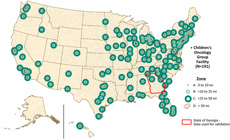
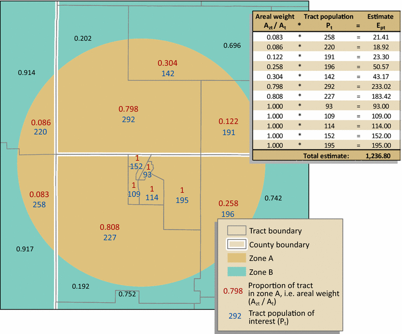
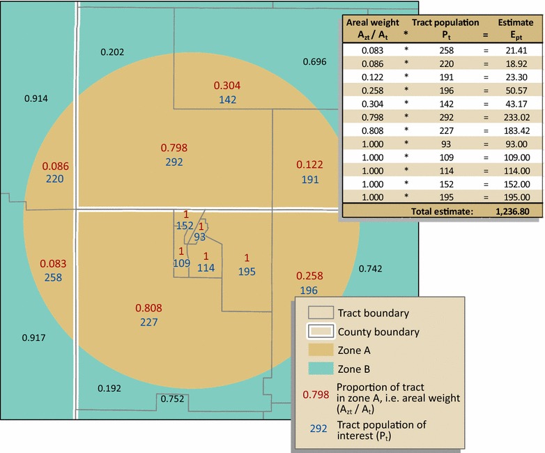
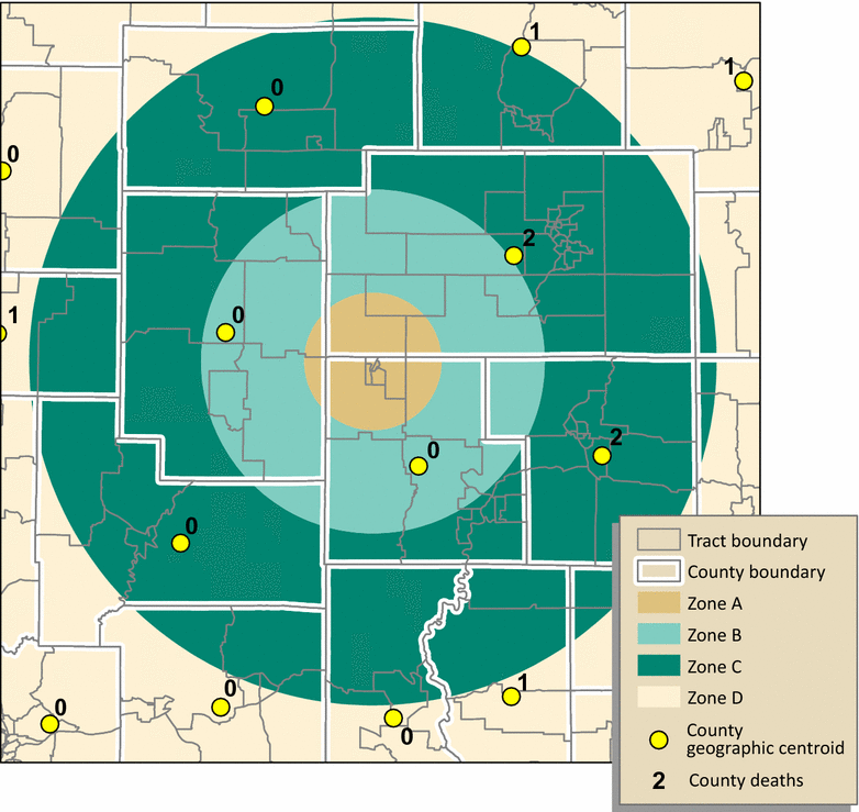
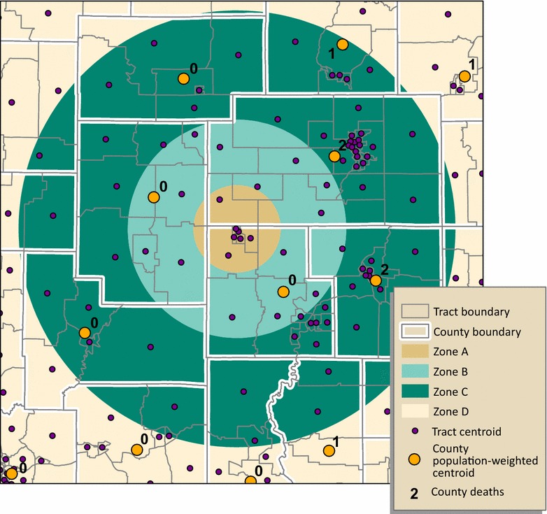
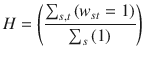
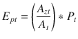
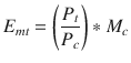
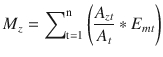
Transforming spatial data from one scale to another is a challenge in geographic analysis. As part of a larger, primary study to determine a possible association between travel barriers to pediatric cancer facilities and adolescent cancer mortality across the United States, we examined methods to estimate mortality within zones at varying distances from these facilities: (1) geographic centroid assignment, (2) population-weighted centroid assignment, (3) simple areal weighting, (4) combined population and areal weighting, and (5) geostatistical areal interpolation. For the primary study, we used county mortality counts from the National Center for Health Statistics (NCHS) and population data by census tract for the United States to estimate zone mortality. In this paper, to evaluate the five mortality estimation methods, we employed address-level mortality data from the state of Georgia in conjunction with census data. Our objective here is to identify the simplest method that returns accurate mortality estimates.
Results
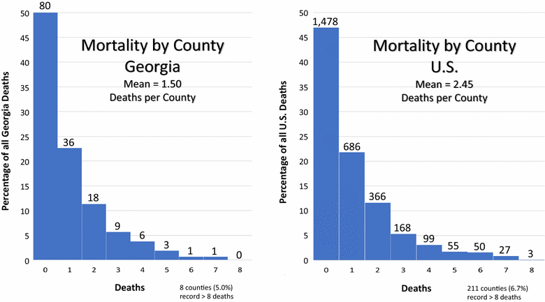
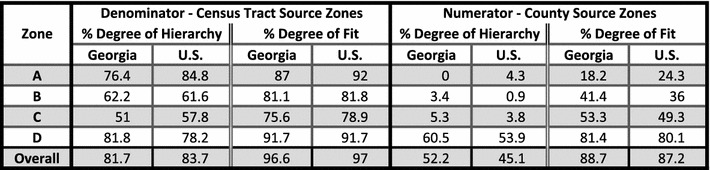
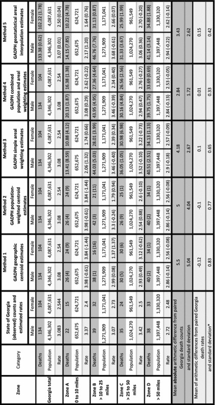
The distribution of Georgia county adolescent cancer mortality counts mirrors the Poisson distribution of the NCHS counts for the U.S. Likewise, zone value patterns, along with the error measures of hierarchy and fit, are similar for the state and the nation. Therefore, Georgia data are suitable for methods testing. The mean absolute value arithmetic differences between the observed counts for Georgia and the five methods were 5.50, 5.00, 4.17, 2.74, and 3.43, respectively. Comparing the methods through paired t-tests of absolute value arithmetic differences showed no statistical difference among the methods. However, we found a strong positive correlation (r = 0.63) between estimated Georgia mortality rates and combined weighting rates at zone level. Most importantly, Bland–Altman plots indicated acceptable agreement between paired arithmetic differences of Georgia rates and combined population and areal weighting rates.
Conclusions
This research contributes to the literature on areal interpolation, demonstrating that combined population and areal weighting, compared to other tested methods, returns the most accurate estimates of mortality in transforming small counts by county to aggregated counts for large, non-standard study zones. This conceptually simple cartographic method should be of interest to public health practitioners and researchers limited to analysis of data for relatively large enumeration units.
-
Subjects:
-
Source:
-
Pubmed ID:28784135
-
Pubmed Central ID:PMC5547484
-
Document Type:
-
Collection(s):
-
Main Document Checksum:
-
Download URL:
-
File Type:
-

gif
jpeg
gif
jpeg
gif
jpeg
gif
jpeg
gif
jpeg
gif
jpeg
gif
jpeg
gif
jpeg
gif
jpeg
bin
gif
gif
gif
gif
gif
gif
gif
 [PDF-3.32 MB]
Details:
Supporting Files


More +


 Email
CDC-INFO
Email
CDC-INFO


