
i
The Topography of Poverty in the United States: A Spatial Analysis Using County-Level Data From the Community Health Status Indicators Project
-
Sep 15 2007
Source: Prev Chronic Dis. 2007; 4(4).
 [PDF-690.97 KB]
Details:
-
Alternative Title:Prev Chronic Dis
-
Personal Author:
-
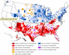
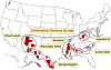
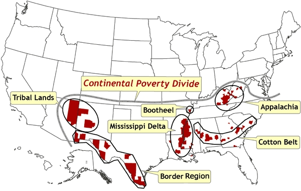
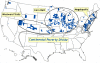
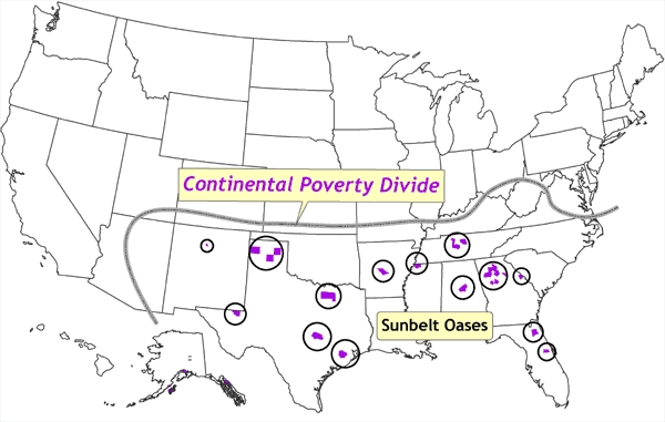
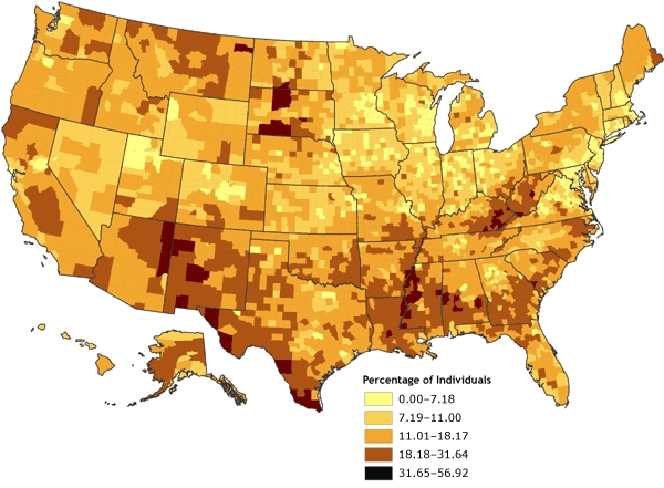
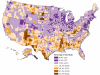
Description:Socioeconomic and health-related data at the county level are now available through the Community Health Status Indicators (CHSI) database. These data are useful for assessing the health of communities and regions. Users of the CHSI data can access online reports and an online mapping application for visualizing patterns in various community-related measures. It also is possible to download these data to conduct local analyses. This paper describes a spatial analysis of poverty in the United States at the county level for 2000. Spatial statistical techniques in a geographic information system were used to quantify significant spatial patterns, such as concentrated poverty rates and spatial outliers. The analysis revealed significant and stark patterns of poverty. A distinctive north-south demarcation of low versus high poverty concentrations was found, along with isolated pockets of high and low poverty within areas in which the predominant poverty rates were opposite. This pattern can be described as following a continental poverty divide. These insights can be useful in explicating the underlying processes involved in forming such spatial patterns that result in concentrated wealth and poverty. The spatial analytic techniques are broadly applicable to socioeconomic and health-related data and can provide important information about the spatial structure of datasets, which is important for choosing appropriate analysis methods.
-
Subjects:
-
Source:
-
Pubmed ID:17875255
-
Pubmed Central ID:PMC2099276
-
Document Type:
-
Place as Subject:
-
Location:
-
Collection(s):
-
Main Document Checksum:
-
Download URL:
-
File Type:
Supporting Files
-

jpeg 
gif 
jpeg 
gif 
jpeg 
gif 
jpeg 
gif 
jpeg 
gif 
xml 
jpeg 
gif 
jpeg 
gif 
jpeg 
gif 
jpeg 
gif


More +
You May Also Like
 [PDF - 317.75 KB]
 [PDF - 163.07 KB]
 Email
CDC-INFO
Email
CDC-INFO


