
i
Comparison of ArcGIS and SAS Geostatistical Analyst to Estimate Population-Weighted Monthly Temperature for US Counties
-
2012
Source: J Resour Ecol. 3(3):220-229
 [PDF-1.31 MB]
Details:
-
Alternative Title:J Resour Ecol
-
Personal Author:
-
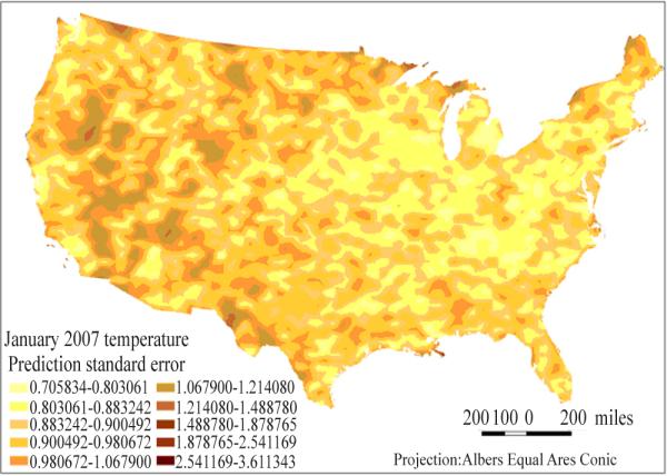
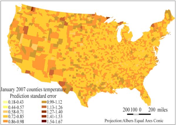
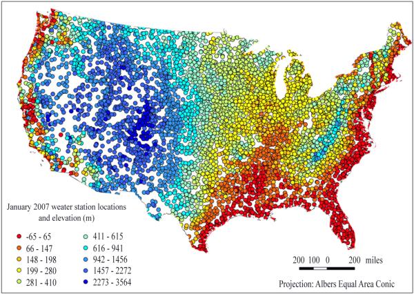
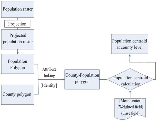
Description:Temperature changes are known to have significant impacts on human health. Accurate estimates of population-weighted average monthly air temperature for US counties are needed to evaluate temperature's association with health behaviours and disease, which are sampled or reported at the county level and measured on a monthly-or 30-day-basis. Most reported temperature estimates were calculated using ArcGIS, relatively few used SAS. We compared the performance of geostatistical models to estimate population-weighted average temperature in each month for counties in 48 states using ArcGIS v9.3 and SAS v 9.2 on a CITGO platform. Monthly average temperature for Jan-Dec 2007 and elevation from 5435 weather stations were used to estimate the temperature at county population centroids. County estimates were produced with elevation as a covariate. Performance of models was assessed by comparing adjusted |, mean squared error, root mean squared error, and processing time. Prediction accuracy for split validation was above 90% for 11 months in ArcGIS and all 12 months in SAS. Cokriging in SAS achieved higher prediction accuracy and lower estimation bias as compared to cokriging in ArcGIS. County-level estimates produced by both packages were positively correlated (adjusted | range=0.95 to 0.99); accuracy and precision improved with elevation as a covariate. Both methods from ArcGIS and SAS are reliable for U.S. county-level temperature estimates; However, ArcGIS's merits in spatial data pre-processing and processing time may be important considerations for software selection, especially for multi-year or multi-state projects.
-
Subjects:
-
Source:
-
Pubmed ID:26167169
-
Pubmed Central ID:PMC4497953
-
Document Type:
-
Collection(s):
-
Main Document Checksum:
-
Download URL:
-
File Type:
Supporting Files
-

jpeg 
gif 
jpeg 
xml 
gif 
jpeg 
gif 
jpeg 
gif 
jpeg 
jpeg 
gif


More +
You May Also Like


MUTHUSI, JACQUES
 ;
;
YOUNG, PETER W.
...
[PDF - 1.41 MB]
 Email
CDC-INFO
Email
CDC-INFO


