
i
Modeling larval malaria vector habitat locations using landscape features and cumulative precipitation measures
-
Jun 06 2014
Source: Int J Health Geogr. 2014; 13:17. -
Alternative Title:Int J Health Geogr
-
Personal Author:
-
Description:Background
Predictive models of malaria vector larval habitat locations may provide a basis for understanding the spatial determinants of malaria transmission.
Methods
We used four landscape variables (topographic wetness index [TWI], soil type, land use-land cover, and distance to stream) and accumulated precipitation to model larval habitat locations in a region of western Kenya through two methods: logistic regression and random forest. Additionally, we used two separate data sets to account for variation in habitat locations across space and over time.
Results
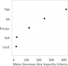
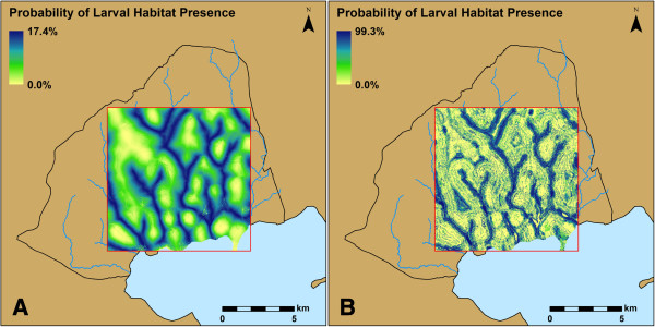
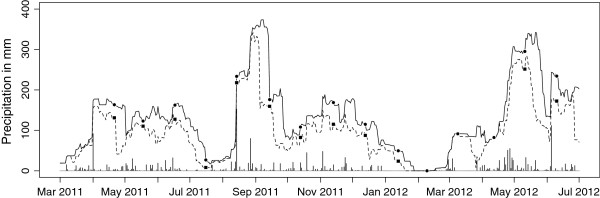
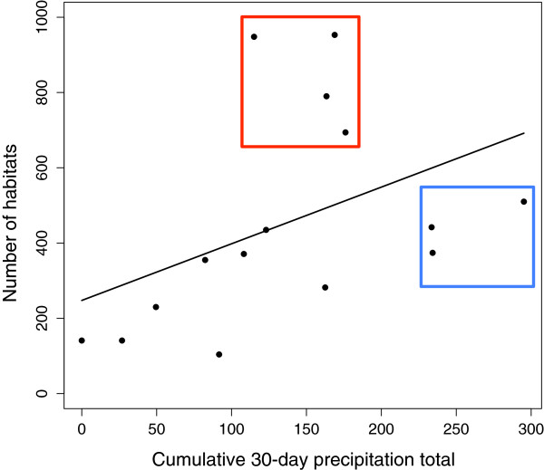
Larval habitats were more likely to be present in locations with a lower slope to contributing area ratio (i.e. TWI), closer to streams, with agricultural land use relative to nonagricultural land use, and in friable clay/sandy clay loam soil and firm, silty clay/clay soil relative to friable clay soil. The probability of larval habitat presence increased with increasing accumulated precipitation. The random forest models were more accurate than the logistic regression models, especially when accumulated precipitation was included to account for seasonal differences in precipitation. The most accurate models for the two data sets had area under the curve (AUC) values of 0.864 and 0.871, respectively. TWI, distance to the nearest stream, and precipitation had the greatest mean decrease in Gini impurity criteria in these models.
Conclusions
This study demonstrates the usefulness of random forest models for larval malaria vector habitat modeling. TWI and distance to the nearest stream were the two most important landscape variables in these models. Including accumulated precipitation in our models improved the accuracy of larval habitat location predictions by accounting for seasonal variation in the precipitation. Finally, the sampling strategy employed here for model parameterization could serve as a framework for creating predictive larval habitat models to assist in larval control efforts.
-
Subjects:
-
Source:
-
Document Type:
-
Place as Subject:
-
Collection(s):
-
Main Document Checksum:
-
Download URL:
-
File Type:
-

gif 
jpeg 
gif 
jpeg 
txt
txt 
gif 
jpeg 
gif 
jpeg 
gif 
jpeg 
gif 
jpeg
 [PDF-1.89 MB]
Details:
Supporting Files


More +


 Email
CDC-INFO
Email
CDC-INFO


