
i
The effect of spatial aggregation on performance when mapping a risk of disease
-
Mar 13 2014
Source: Int J Health Geogr. 2014; 13:9. -
Alternative Title:Int J Health Geogr
-
Personal Author:
-
Description:Background
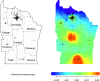
Spatial data on cases are available either in point form (e.g. longitude/latitude), or aggregated by an administrative region (e.g. zip code or census tract). Statistical methods for spatial data may accommodate either form of data, however the spatial aggregation can affect their performance. Previous work has studied the effect of spatial aggregation on cluster detection methods. Here we consider geographic health data at different levels of spatial resolution, to study the effect of spatial aggregation on disease mapping performance in locating subregions of increased disease risk.
Methods
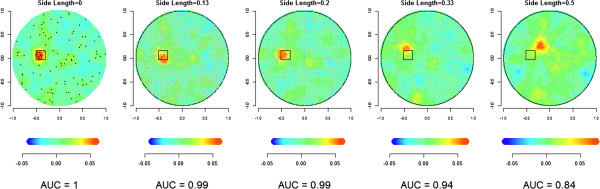
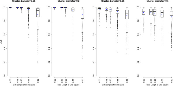
We implemented a non-parametric disease distance-based mapping (DBM) method to produce a smooth map from spatially aggregated childhood leukaemia data. We then simulated spatial data under controlled conditions to study the effect of spatial aggregation on its performance. We used an evaluation method based on ROC curves to compare performance of DBM across different geographic scales.
Results
Application of DBM to the leukaemia data illustrates the method as a useful visualization tool. Spatial aggregation produced expected degradation of disease mapping performance. Characteristics of this degradation, however, varied depending on the interaction between the geographic extent of the higher risk area and the level of aggregation. For example, higher risk areas dispersed across several units did not suffer as greatly from aggregation. The choice of centroids also had an impact on the resulting mapping.
Conclusions
DBM can be implemented for continuous and discrete spatial data, but the resulting mapping can lose accuracy in the second setting. Investigation of the simulations suggests a complex relationship between performance loss, geographic extent of spatial disturbances and centroid locations. Aggregation of spatial data destroys information and thus impedes efforts to monitor these data for spatial disturbances. The effect of spatial aggregation on cluster detection, disease mapping, and other useful methods in spatial epidemiology is complex and deserves further study.
-
Subjects:
-
Source:
-
Pubmed ID:24625068
-
Pubmed Central ID:PMC3995615
-
Document Type:
-
Funding:
-
Place as Subject:
-
Collection(s):
-
Main Document Checksum:
-
Download URL:
-
File Type:
-

gif 
jpeg 
txt
txt 
gif 
jpeg 
gif 
jpeg 
gif 
jpeg 
gif 
jpeg
 [PDF-1.73 MB]
Details:
Supporting Files


More +
You May Also Like
 [PDF - 5.67 MB]
 [PDF - 621.73 KB]
 Email
CDC-INFO
Email
CDC-INFO


