
i
Effects of georeferencing effort on mapping monkeypox case distributions and transmission risk
-
6 27 2012
Source: Int J Health Geogr. 2012; 11:23 -
Alternative Title:Int J Health Geogr
-
Personal Author:
-
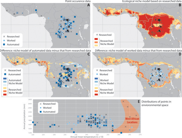
Description:Background
Maps of disease occurrences and GIS-based models of disease transmission risk are increasingly common, and both rely on georeferenced diseases data. Automated methods for georeferencing disease data have been widely studied for developed countries with rich sources of geographic referenced data. However, the transferability of these methods to countries without comparable geographic reference data, particularly when working with historical disease data, has not been as widely studied. Historically, precise geographic information about where individual cases occur has been collected and stored verbally, identifying specific locations using place names. Georeferencing historic data is challenging however, because it is difficult to find appropriate geographic reference data to match the place names to. Here, we assess the degree of care and research invested in converting textual descriptions of disease occurrence locations to numerical grid coordinates (latitude and longitude). Specifically, we develop three datasets from the same, original monkeypox disease occurrence data, with varying levels of care and effort: the first based on an automated web-service, the second improving on the first by reference to additional maps and digital gazetteers, and the third improving still more based on extensive consultation of legacy surveillance records that provided considerable additional information about each case. To illustrate the implications of these seemingly subtle improvements in data quality, we develop ecological niche models and predictive maps of monkeypox transmission risk based on each of the three occurrence data sets.
Results
We found macrogeographic variations in ecological niche models depending on the type of georeferencing method used. Less-careful georeferencing identified much smaller areas as having potential for monkeypox transmission in the Sahel region, as well as around the rim of the Congo Basin. These results have implications for mapping efforts, as each higher level of georeferencing precision required considerably greater time investment.
Conclusions
The importance of careful georeferencing cannot be overlooked, despite it being a time- and labor-intensive process. Investment in archival storage of primary disease-occurrence data is merited, and improved digital gazetteers are needed to support public health mapping activities, particularly in developing countries, where maps and geographic information may be sparse.
-
Subjects:
-
Source:
-
Pubmed ID:22738820
-
Pubmed Central ID:PMC3724478
-
Document Type:
-
Collection(s):
-
Main Document Checksum:
-
Download URL:
-
File Type:
-

gif 
jpeg 
gif 
jpeg 
gif 
jpeg 
xml
 [PDF-1.81 MB]
Details:
Supporting Files


More +
You May Also Like
 [PDF - 621.73 KB]
 [PDF - 1.31 MB]
 Email
CDC-INFO
Email
CDC-INFO


